 Southwest
Environmental LimitedSouthwest
Environmental Limited
Southwest
Environmental LimitedSouthwest
Environmental Limited| London |
| 02076 920 670 |
| Exeter |
| 01392 927 961 |
| Manchester |
| 01612 970 026 |
| Bristol |
| 01173 270 092 |
SWEL can provide a flood risk assessment report for sites in
any part of the
UK, our standard report includes the
sequential test, the
exceptions test and a
basic
surface water management plan.
Flood Risk Assessment is now a common part of planning in any new development,
and you may well be asked to complete one in the planning stage
of a project, you may be asked for a flood risk report during
the planning phase.
Where will SWEL undertake a Flood Risk Assessment?
The need for a FRA originates from the Pitt Review findings
which has manifested its self in PPS 25 (Planning Policy
Statements), and then from March 2012 the new Planning Policy
Frame Work and its Technical Guidance.
Flood Risk Reports look at the sites characteristics and
tries to gauge the risk of flooding.
Site Specific Flood Risk Assessment is used to establish flood risk for large sites such as housing developments, to where surface water management and flood data may have to be gather in a site specific context. However in most cases for small to medium sized projects a single phase flood risk report is all it takes to satisfy planning conditions.
Designing Buildings for Flooding
SWEL have considerable experience in demonstrating the
sequential test for small and large scale planning applications. Our method
for the
sequential test has met with 80% to 90% acceptance with a variety of local
planning authorities.
Please feel free to telephone the office for an informal discussion
regarding any of the services we provide.
Disclaimer - Information on this Site
A Flood Risk Assessment Screening Study is the least complicated of the three main flood risk report types. It is suitable for sites that are required to submit FRA Reports, but are sited in low risk areas. It is also useful if you are looking to buy development land, or if you are "vetting" a large property portfolio to describe risks for individeual assets.
Flood Risk Assessment Scoping Study is really an intermediate stage between screening and detailed study. This may outline what will be required in a detailed study, say to support a planning application. For our clients a scoping study would likely take the form of a note, or long email describing what data collection exercises might need to be carried out.
In some cases planners may ask for a Flood Risk Assessment, but in reality they really mean a surface water drainage stragey. So this scoping stage can also provide a sanity check prior to the real work commencing.
A Flood Risk Assessment Scoping Report will indicate if certain information sources should be consulted, or indeed are needed. Quite often there is balance to be made between the cost of out service, and the minimum requirements to make a successful planning application.
Over the years we have developed quite a strong understanding of what information is required in a Flood Risk Assessment and as such we know what to include.
A Flood Risk Assessment Detailed Study is the most complicated of the three main flood risk report types. It is suitable for large sites that are required to submit FRA Reports, which can be sited in low, medium or high risk areas.
Whilst a Flood Risk Assessment Detailed Study Report could extend to contain the following information, it rarely does. The below list is information that could be asked for, but we are very rarely required to provided he whole list, although around 60% of below item are referenced or included.
Walkover survey to assess:
A temporary “safe refuge” - is any place or structure where individuals trapped by floodwater (those who did not receive or ignored flood warnings) can remain for a short period in relative safety whilst awaiting rescue thus lowering flood risk. Provision of refuges within buildings makes developments safer and lowers risk of flood related harm. PPG states - safe refuges play a role in reducing the overall risk of flooding.
Safe refuges should be above the 0.1%AEP event tide level at the end of the development’s life. Effectively this means most buildings in the flood plain need to be greater than 1 story high.
Please feel free to contact the office for an informal discussion regarding your requirements. Safe Refuge Page.
Finished Floor Levels:
Finished floor levels must take in to account level rises from climate change.
Please feel free to contact the office for an informal discussionregarding your flood risk report requirements.
| Material | Water Penetration | Drying Ability | Retention of pre-flood dimensions |
| Bricks | |||
| Engineering bricks (Classes A and B) | Good | Good | Good |
| Facing bricks (pressed) | Medium | Medium | Good |
| Facing bricks (handmade) | Poor | Poor | Poor |
| Blocks | |||
| Concrete (3.5N, 7N) | Poor | Medium | Good |
| Aircrete | Medium | Poor | Good |
| Timber board | |||
| OSB2, 11mm thick | Medium | Poor | Poor |
| OSB3, 18mm thick | Medium | Poor | Poor |
| Gypsum plasterboard | |||
| Gypsum Plasterboard, 9mm thick | Poor | Poor | Poor |
| Mortars | |||
| Below d. p.c. 1:3(cement:sand) | Good | Good | Good |
| Above d. p.c. 1:6(cement:sand) | Good | Good | Good |
General advice for Resilient Design
Where concrete ground floor slabs are used, the block work substructure is often the weakest point in terms of water penetration from the ground into a dwelling. Whereas there is a general perception that water can ingress through the block work structure of the external face of a wall into the property, it is less apparent, but equally possible, that water will penetrate from the ground on the inside of the pro perty. Figures 6.2 and 6.3 illustrate these flow paths for two types of ground floor (ground bearing floor and suspended concrete floor), and different types of foundation (typical for construction in England). Concrete blocks used in foundations should be sealed with an impermeable material or encased in concrete to prevent water movement from the ground to the wall construction.
| Flood Resistant |
|
Flood Resistant – prevent the building
from flooding. A “water exclusion strategy”. OK if you aren’t expecting more than 300mm flood depth.
For Example: Vent Covers
|
| Flood Resilient |
|
Flood Resilient – Doesn’t get too badly
damage when it gets wet. A “water entry strategy”. Reduces risk of damage from water pressure on wall when flooding 600mm or more. Flood resilient design is applicable when you expect the site to be flooding to excessive depths. When choosing flood resilient design as your strategy you should pick materials that do not deform when wet, and can be dried out easily. By example: When choosing walls you should avoid stud partitioning with "wool" type insulation. Plaster board does not react well in being wet, and the gaps within the wall will be tricky to dry out. A better option would be to use light weight block work walls, with a smooth render. Flood resilient measures need only be applied up to the design flood level. A "free board" is often added, to guard against negative effects of capillary action.
|
.png) Using GIS Southwest Environmental can produce
custom flood maps for any area. These can be on a local of regional
scale. Maps are based on existing flood risk data as supplied by the
Environment Agency. We can also add climate change allowances, which are
often not represented in existing mapping.
Using GIS Southwest Environmental can produce
custom flood maps for any area. These can be on a local of regional
scale. Maps are based on existing flood risk data as supplied by the
Environment Agency. We can also add climate change allowances, which are
often not represented in existing mapping.
Mapping Data can include Flood Risk Zone 2 and Flood Risk Zone 3, also
flood storage areas.
Also available are flood hazard area maps, and flood warning area maps.
These can be presented on any base map as requested either low
resolution open source mapping (open street map) or on high detail OS
master maps, at additional costs.
This services is most useful for larger areas,
parish councils for example.
Flood Zone
Modelling is a different services which involve the modeling of
flood zones using computerised calculations with specialist software.
We will carry out a Flood Risk Assessment in any part of the UK, we have offices in London, Bristol and Exeter.
Please feel free to contact the office for an informal discussion regarding your requirements.
Breach Modeling for Flood Risk Assessment
SWEL will be happy to carry out a breach modeling assessment for a specific site, using ISIS software we can perform 1D or 2D model runs.
Breach modeling can be particularly useful in determining planning applications, where site safety is questioned, the Environment Agency may well raise objections to a site where there is an un-quantified risk with regards to breach inundation.
What is a Flood Consequence Assessment?
If your site is in wales then you may require a Flood Consequence Assessment as an alternative to a Flood Risk Assessment. TGN 15 describes the process:
"Whether a development should proceed or not will depend upon whether the consequences of flooding of that development can be managed down to a level which is acceptable for the nature/type of development being proposed, including its effects on existing development. It would certainly not be sensible for people to live in areas subject to flooding (even in two story buildings) where timely flood warnings cannot be provided and where safe access/egress cannot be achieved."
To describe
the approach taken for achieving credits under
BREEAM section Pol 03 (5 credits available). With the aim of:
“Avoid (ing),
reduce (ing) and delay (ing) the discharge of rainfall to public sewers and
watercourses, therefore minimising the risk of localised flooding on and off
site, watercourse pollution and other environmental damage.”
The gaining of these 3 valuable points are based on flood risk, surface water drainage and water course pollution. SWEL typically seek to gain the full 5 points in every instance, we have not issued a report to date that has not gained 5 points under BREEAM scoring system.
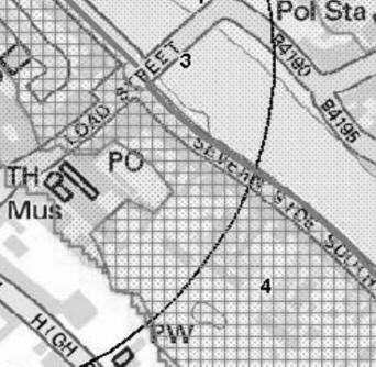
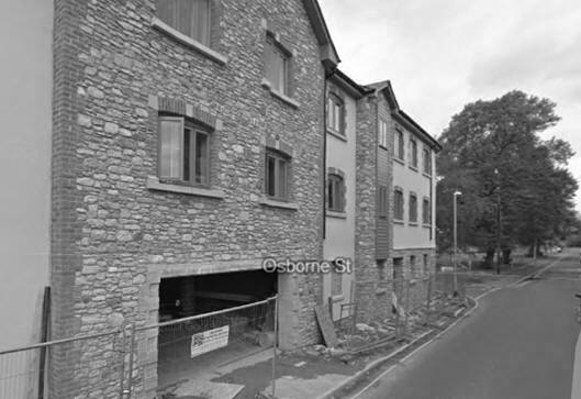
Working in support of planning application 15/00760/FUL SWEL Produce a Flood Risk Assessment and Surface Water Management Plan. The application site was in Zone 3a. Various recommendations were made in relation to the suitability of the site in relation to the proposed development. The application was successful.
Below listed are a selection of flood risk assessment case studies from our project blog.
Flood Risk
Assessment Bristol
Flood Risk
Assessment Exeter
Flood Risk
Assessment London
|
S.D. Content Flood Risk Consultants Bristol - 01173 270 092 Exeter - 01398 331 258 London - 02076 920 670 |
|