 Southwest
Environmental LimitedSouthwest
Environmental Limited
Southwest
Environmental LimitedSouthwest
Environmental Limited| London |
| 02076 920 670 |
| Exeter |
| 01392 927 961 |
| Manchester |
| 01612 970 026 |
| Bristol |
| 01173 270 092 |
Sometimes if it is discovered that you project lies within flood
zone 2 or 3, it will be stipulated by you local planning authority that
you may need a Flood Risk Assessment, although this is perceived by most
as an annoyance, and its certainly can be that, a
flood risk assessment
can contain useful information such as finished floor levels, and
material choices.
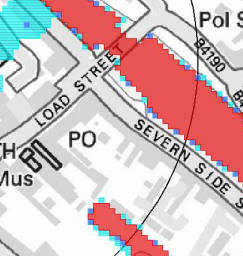
Flood risk maps
that have been made by the environment agency and their consultant
partners, are based on fluvial and marine flooding only, and do not take
in to account surface water flooding (separate maps see below) and sewer
flooding where large volumes of water can be transferred from one area
to another through the sewer network.
So a flood risk assessment, based on available data is by no means fool
proof, but more often than not will prove that your site is low risk
(hopefully) or a bit of a nightmare.
 Depending on what flood plains
you are in will depend on what you can build as outlined by
PPS 25.
Depending on what flood plains
you are in will depend on what you can build as outlined by
PPS 25.
However, chances are if you are building in the flood plan area, you
will have taken advice from your LPA or the EA.
I you have a worry about anything give us a buzz and we will try to
explain, you will get charged for a report but not for informal chit
chat.
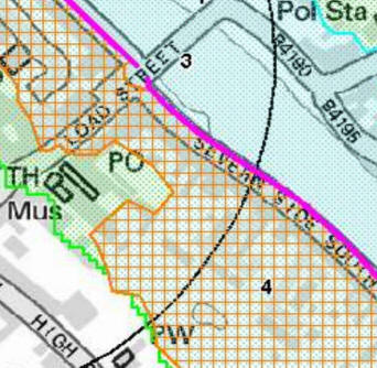
In the case of the project near the map area above, even though the site
was situated within the flood zone 2, it was allowed to go ahead, for
the following reasons:
1 - The type of project matched established uses for flood zone area 2
uses. That was good.
2 - There were questions over the resolution of the mapping, it appeared
the site was on a raised area of ground not accounted for in the maps.
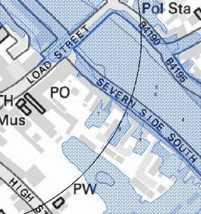
Historic Flood extent
maps (left) and surface flooding maps are also used to compile data and
flood risk for a site.
Key Parts of Flood Risk Assessment
1 -
Exception Test
2 -
Sequential Test
3 -
Surface Water Management Plan
4 -
Safe Refuge Designation
5 -
Scoping or
Screening
If you have any questions regarding discharge consents whether existing or proposed then please contact SWEL, and we will offer you (of course) a free of charge initial consultation.
The below section was written by a machine.
The below section was written by a machine.
Adjusting flood zones for climate change is a mandatory requirement for any robust Flood Risk Assessment (FRA). Current Environment Agency guidance requires developers to account for increased peak river flows and sea level rise over the anticipated lifetime of a development, ensuring that new infrastructure remains resilient to future environmental shifts.
Climate change allowances vary depending on the river basin district and the vulnerability of the proposed land use. Technical adjustments typically involve:
Increased rainfall intensities also dictate the design of Sustainable Drainage Systems (SuDS). By accurately mapping future flood extents using flood depth GIS mapping, we can ensure that surface water management features are not situated within functional floodplains.
With 15 years of industry experience and 900+ projects delivered, Southwest Environmental Limited provides the expert authority needed to navigate climate change legislation. Our consultants hold professional accreditations (IES, IAQM) and provide evidence-based analysis to satisfy Lead Local Flood Authorities across the UK. Whether you are managing nutrient neutrality or seeking pre-application advice, we provide the technical clarity required for long-term project success.