 Southwest
Environmental LimitedSouthwest
Environmental Limited
Southwest
Environmental LimitedSouthwest
Environmental Limited| London |
| 02076 920 670 |
| Exeter |
| 01392 927 961 |
| Manchester |
| 01612 970 026 |
| Bristol |
| 01173 270 092 |
A Visual and Landscape Impact Assessment is a collection of written and visual (images) information that attempts to explain and gauge impacts of a proposed development on visual amenity and the Landscape.
If you would like SWEL to prepare a report for you, deliver in PDF or HTML format we can do so. Please contact us for a fixed price quotation.
The European EIA directives and UK environmental regulations state that the impact of a development on the visual aspects of a landscape should be assessed. Guidance comes from the Landscape Institute amongst others.
The Landscape is
described as encompassing the following features:
-Natural Factors such as geological features,
land, air, soils, flora and fauna.
-Cultural / Social settles, enclosures, structures
-Aesthetic and Perceptual factors such as colour,
texture, sounds, and smells.
So is the area you are planning to build an areas which is visually sensitive? A map has been published by the Countryside Commission and English Nature called The Character of England Map.
 |
The Character of England Map for which we are
viewing the southwest quadrant can be visited
here. If we were to click on a segment we would be shown a list of the landscape characteristics; -Rolling, locally steeply-undulating open, pasture separated by many small valleys. -Heavy, poorly-drained soil supporting rushy pastures of low agricultural quality but high nature-conservation interest. -Wide views across a remote landscape. -Little tree cover except occasional wind-shaped hedgerow and farmstead trees, conifer blocks and valley woodlands. |
Reading of such characteristic can help envisage a development that might make use of the landscape in the area to minimise its visual impact.
Qualitative Visual Impact Assessment
| Visual Impact
Assessment is thought by many to be a very subjective discipline, using
modern 3D modeling it is possible to create scaled representations of
proposed developments, so we can look at impacts before they are built.
But in reality does this give a measured impact? Qualitative Visual Impact Assessment gives a good indication of negative impacts, but for large projects with far reaching implications a quantitative visual impact assessment is a better option. That being said under current legislative requirements a qualitative visual impact assessment is sufficient for planning applications. |
 |
Quantitative Visual Impact Assessment
|
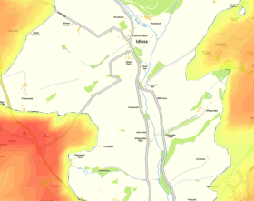
Assessing Impact on a quantitative basis is accomplished using a ZTV (zone of theoretical visibility), and is present on a OS map base, zones on the map are presented as a % of the structure visible from that particular point. These factors and others will be assessed in the visual impact component of an environmental impact assessment. Please contact us if you have a need of visual impact assessments, or take a look at an example Visual Impact Assessment |
 |
The assessment of cumulative effects is a statutory requirement under the EIA Directive (85/337/EEC) and the UK EIA Regulations. These effects are defined as impacts resulting from multiple actions on environmental receptors and resources, occurring either from a single project or in combination with other nearby developments.
“Additional changes to the landscape or visual amenity caused by a proposed development in conjunction with other developments (associated with or separate to it), or actions that occurred in the past, present, or are likely to occur in the foreseeable future.”
For example, in a recent assessment of the Allen Valley, our study identified significant existing infrastructure, including multiple 50-meter high pylons running along the high ground. These must be considered alongside existing agricultural structures—such as livestock and grain storage sheds ranging from 6 to 9 meters in height—to determine the total 'in-combination' change to the landscape character.
Click the above link to read about a Visual Impact Assessment carried
out for a multistory building in Rickmansworth, Hertfordshire.
Visual Impact Assessment for Wind Turbine
Click the above link to read about a Visual Impact Assessment carried
out for Wind Turbine in Cornwall
A Visual and Landscape Impact Assessment (LVIA) is a critical component of the planning process, designed to evaluate how a proposed development will alter the aesthetic and physical characteristics of its surroundings. Whether for a single wind turbine or a large-scale urban development, our assessments follow the Landscape Institute (GLVIA3) guidelines to ensure technical robustness. This reporting is vital for any planning application where the height or scale of a project may impact designated vistas or sensitive landscape character areas.
We provide both qualitative and quantitative approaches tailored to site-specific needs. For urban developments—such as our work on multi-story residential projects in Rickmansworth, Hertfordshire—a Qualitative Visual Impact Assessment is often utilized to gauge impacts on visual amenity. For larger infrastructure, we employ Quantitative ZTV (Zone of Theoretical Visibility) analysis. Using GIS data, we calculate exactly where a structure is visible from, which is a mandatory requirement for major Environmental Impact Assessments (EIA) across Devon, Cornwall, and the wider UK.
A central pillar of our LVIA service is the assessment of Landscape Character. We utilize "The Character of England Map" to audit natural factors (geology, flora, fauna) and aesthetic perceptions. Our team also specializes in Cumulative Visual Impact Assessments, analyzing how a proposed development works "in-combination" with existing or planned projects. This was a key factor in our Cornwall Wind Turbine case study, where we modeled the cumulative impact of renewable energy infrastructure against a backdrop of existing pylons and agricultural structures to satisfy the UK EIA Regulations.
Where potential negative impacts are identified, we use 3D modeling and visualisations to design effective mitigation. This can include architectural modifications, material selections, or strategic screen planting to help a development "blend" into the landscape. These measures are frequently integrated into your Planning Statement, providing the scientific evidence needed to secure project approval while maintaining Biodiversity Net Gain (BNG) and respecting the local "sense of place."
Providing verifiable, professional visual assessments is essential for satisfying planning officers and statutory consultees. Our reports provide "True Data" through ZTV modeling and professional visualisations. With over 900 projects successfully delivered across the UK, SWEL brings the technical authority and professional accreditation (Landscape Institute / IES) required to navigate complex visual constraints and secure your project’s planning consent in sensitive environments.