Category Archives: BNG Assessment

Photogrammetry Work Flow – Linux: Step by Step

Drone Surveys in the Environmental Consultancy Sector

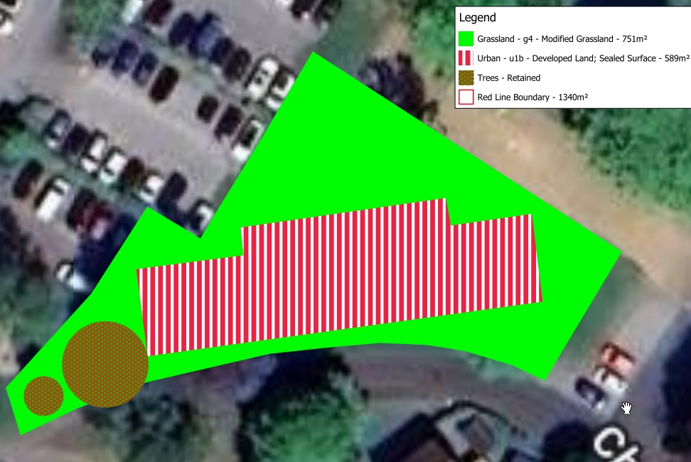
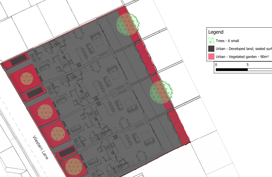
In the commercial sector, consultancies rely heavily on accurate topographical models and 3D visualizations to conduct Landscape and Visual Impact Assessments (LVIA)—such as modeling the visual footprint of proposed wind turbines—or to establish accurate site baselines for Preliminary Ecological Assessments.

The processing was conducted entirely on open-source Linux software. The hardware utilized was a Lubuntu workstation equipped with an Intel Core i9, an NVMe SSD, and 16GB of RAM. While the processor and storage speeds were more than adequate, the 16GB memory capacity required some careful resource management during the heavier processing phases.

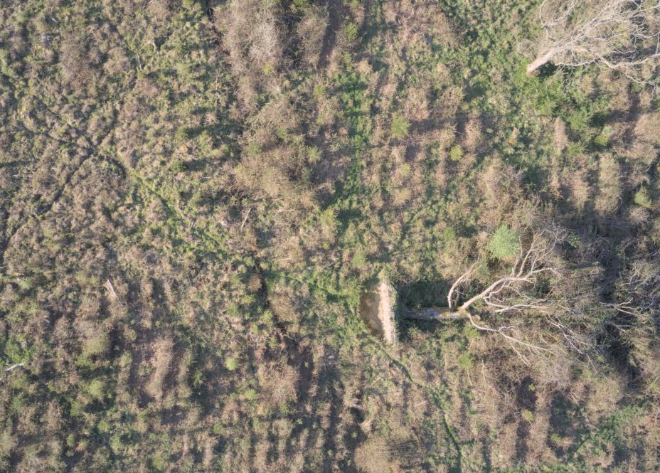
44 images like this one used to create mesh (the fallen tree is a good reference point)

Phase 1: Flight Planning and Data Acquisition

A 2D flight grid was plotted using a web-based mission planner (Drone Grid), and the resulting CSV was imported into Litchi to run on the drone controller.

Rather than relying on automated distance-based photo triggers—which can occasionally misfire or skip photos during curved maneuvers—a manual interval approach was utilized (Litchi). The drone was placed in a hover, the camera was set to a 2-second interval, and the shutter was manually engaged before initiating the mission. This ensured a continuous, reliable stream of overlapping images as the drone navigated the grid.

Phase 2: Dataset Culling and Format Conversion

Once the flight was completed, a quality control check was performed on the dataset. Any extraneous photos captured during takeoff, landing, or non-nadir (not pointing straight down) turns were removed, as these irregular angles can confuse the photogrammetry software and corrupt the final geometry.

Initially, the drone was set to capture RAW (.DNG) files. While RAW formats are excellent for standard photography, they lack the automated lens-flattening corrections applied to DJI’s JPEGs. Furthermore, uncompressed RAW files are heavily taxing on system memory during 3D processing.

To rectify this, the DNGs were imported into darktable on Linux. A batch lens correction profile was applied to eliminate the fish-eye distortion, and the dataset was exported as high-quality JPEGs. (Note: moving forward, capturing JPEGs natively on the drone is highly recommended to bypass this conversion step entirely).

Phase 3: Processing in WebODM

WebODM (OpenDroneMap), deployed via Docker, was used for the photogrammetry processing.

The 3D texturing phase of photogrammetry is notoriously memory-intensive, and the 16GB of system RAM was quickly identified as a bottleneck. To prevent Docker from running out of memory and crashing the process, the Resize Images parameter within WebODM’s settings was capped at 2048. This significantly reduced the memory footprint during the dense point cloud and meshing phases, allowing the i9 processor to complete the job smoothly while leveraging the fast swap/read speeds of the NVMe drive.

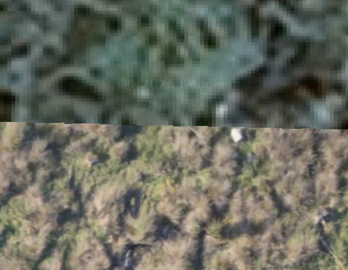
Top Google Satellite Image / Bottom Ortho Mesh Photo Output from WebOMD

Phase 4: Output Visualization

Once the processing concluded, the 2D orthomosaic was reviewed directly within the WebODM web interface. The software successfully stitched the dataset into a crisp, seamless top-down map, providing an excellent baseline of the site.
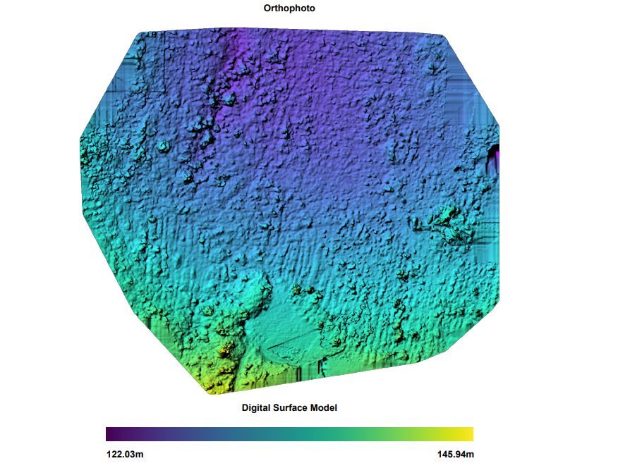
DSM From Drone Data

Viewing the 3D output required a slight workaround. Rendering a massive, fully-textured 3D mesh directly in the browser via WebGL can sometimes cause instability depending on Linux graphics drivers. Instead, the .obj file and its associated texture map were downloaded and opened natively in Blender.

Because 3D software often disagrees on coordinate systems, the mesh imported on its side. This was quickly corrected by rotating the model 90 degrees on the X-axis. Once the material preview was enabled, the high-resolution texture map was projected onto the geometry, yielding a mathematically accurate, true-to-life 3D representation of the area.

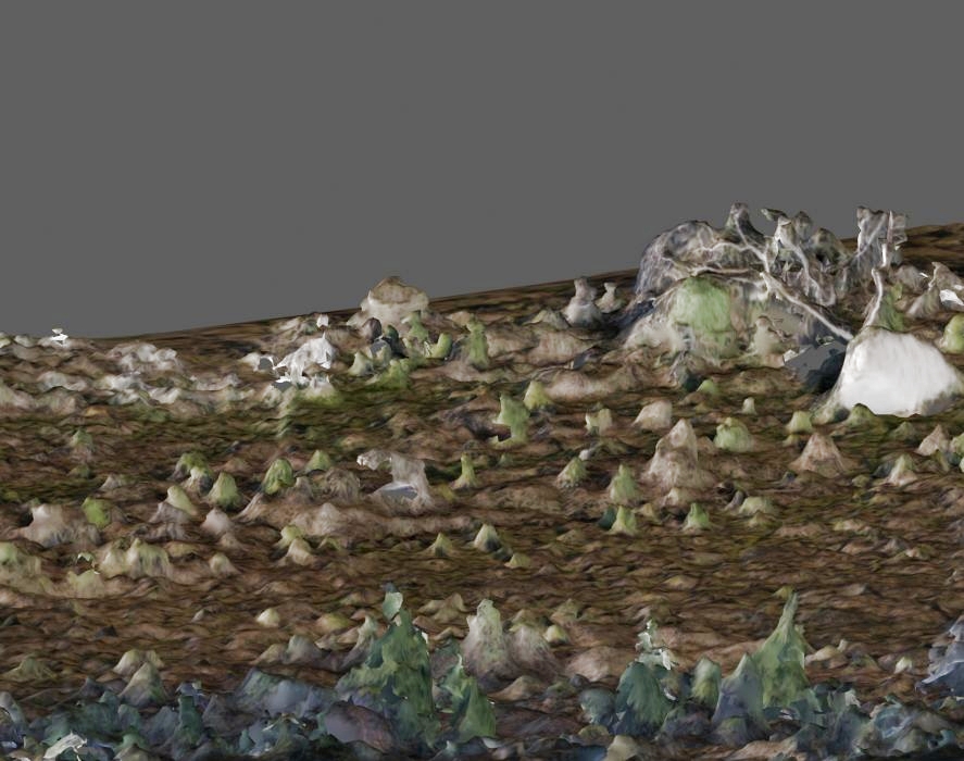
3D Mesh Image (Note the white shape to the top right is root ball of fallen tree)

Conclusion

By effectively managing hardware limits and ensuring the dataset is properly formatted, commercial-tier photogrammetry can be reliably executed on a standard Linux workstation. The resulting 2D and 3D outputs now serve as a foundational geospatial baseline.

The New 0.2 ha BNG Exemption

Big Changes for Small Sites: The New 0.2 ha BNG Exemption

This 0.2ha rules will come in to force sometime in the first half of 2026.

New Biodiversity Net Gain (BNG) Exemption for Small Sites

The UK government has announced a significant shift in Biodiversity Net Gain (BNG) requirements to support small-scale developers. As of December 2025, the housing minister confirmed that developments on sites smaller than 0.2 hectares will be exempt from the mandatory 10% BNG requirement.

What is Changing? Previously, even small sites were required to demonstrate a 10% increase in biodiversity, often using the Small Sites Metric (SSM). Under the new policy, sites with a total area under 0.2 hectares will no longer be required to meet this statutory 10% uplift. This threshold was selected as a compromise after earlier proposals suggested exempting sites up to 0.5 hectares.

Red Line or Built Area?

Measurement and Site Area The 0.2-hectare threshold is based on the entire site area as defined by the red line boundary of the development. It is not limited to the built area or the developed footprint. This means that if the total area within your red line boundary is 0.2 hectares or more, the exemption will not apply, even if your actual building footprint is very small.

Which Metric Do I Use?

Metric Calculators for Larger Sites For sites that exceed the 0.2-hectare threshold but are still classified as small sites (typically up to 9 dwellings or less than 1 hectare for residential), the Small Sites Metric (SSM) remains the primary tool. However, if a site is over 0.2 hectares and contains “priority habitats” (such as ancient woodland or specific grasslands), the more complex Statutory Biodiversity Metric must be used instead.

Why the Change? The primary goal is to reduce the administrative and financial burden on SME housebuilders. For micro-sites, the cost of ecological surveys and the requirement to secure 30-year management plans were often seen as disproportionate to the environmental impact. By removing these hurdles, the government aims to accelerate the delivery of infill housing and urban development.

Current Status and Parliament Timeline The government’s formal response to the BNG consultation and the full implementation timeline are expected in early 2026. Because this change requires secondary legislation to become law, it must be laid before Parliament as a Statutory Instrument. While a specific day has not yet been set, the legislative process is expected to move forward in the first half of 2026. Until this legislation is officially enacted and brought into force, the existing BNG rules—including the 10% mandate for small sites—remain the legal requirement.

Additional Consultations Alongside the 0.2-hectare rule, the government is consulting in early 2026 on a further exemption for residential brownfield sites up to 2.5 hectares. This is intended to incentivize development on previously used land with low ecological value.

If you need help with anything Ecological including BNG please Contact Us

BNG Assessments London

London BNG Expertise: Over 20 Assessments in the Last Year

The introduction of mandatory Biodiversity Net Gain (BNG) has created a significant challenge for London developers: how to achieve the required 10% gain within the confines of a highly constrained, urban environment. At SWEL, we have rapidly mobilised our ecological expertise to meet this demand, completing over 20 BNG assessments across various London boroughs in the last year alone.

Top Tip: Please don’t do any site clearance works before you have spoken to our ecologists. It could cost you a great deal of money if chop down a valuable tree (£25,000 per tree).

This hands-on experience has equipped us with the proven strategies needed to navigate the complexities unique to the capital. While many developments have zero or low ecological baselines, the London Plan demands meaningful contributions to green infrastructure. Our track record shows we successfully apply the statutory Defra Metric to urban sites, identifying creative solutions such as:

  • Urban Greening Factor (UGF) Integration: Ensuring BNG designs complement and achieve the borough’s Urban Greening Factor targets.
  • Green Roofs and Walls: Maximising ‘high distinctiveness’ habitats in limited space.
  • Off-site Unit Planning: Securing and allocating registered off-site BNG units where on-site delivery is not physically possible.

Example Plans Created by SWEL’s Ecologist

Rapid Response: Qualified Ecologists Ready for Your Project

We understand that delays in planning can be costly. The challenge faced by many Local Planning Authorities (LPAs)—which often lack the in-house ecological expertise and are reporting staff shortages—can slow down the BNG verification process.

To directly address this speed bottleneck, SWEL has a dedicated team of suitably qualified proactive and personable ecologists standing ready to deliver your assessment on a rapid turnaround. Our experts are proficient in the latest statutory metric and the nuanced requirements of individual London Boroughs. By submitting a robust, accurate BNG Assessment and Habitat Management Plan (HMP) from day one, we help your application move through the system efficiently, avoiding unnecessary requests for further information and reducing your time to consent.

On-Site Mitigation?

Our service goes beyond simply calculating your Biodiversity Net Gain (BNG) deficit; we provide comprehensive strategies for achieving the mandatory 10% net gain, regardless of your site’s complexity. We offer expert advice on both on-site mitigation—designing and integrating ecologically valuable habitats such as green roofs, sustainable drainage features (SuDS), and enhanced landscaping directly into your development plans—and securing off-site BNG credits. Whether your London site is too constrained for on-site delivery, or you need a rapid solution, we guide you through the process of legally purchasing and allocating credits from registered off-site providers, ensuring your project achieves the necessary net gain quickly and compliantly for local authority approval.

Another Example Plan From a BNG Assessment

In conclusion, partnering with Southwest Environmental for your London Biodiversity Net Gain assessment delivers both unrivalled expertise and critical efficiency. Our proven track record of successfully navigating over ten complex BNG assessments in urban settings over the past year, combined with our strategic advice on both on-site design and off-site credits, ensures a compliant and pragmatic path to planning consent. When time is money and regulatory detail is paramount, trust SWEL’s team of qualified ecologists to provide the rapid, robust, and reliable BNG solutions you need to keep your London development on schedule and ethically sound. Contact us today to secure your swift BNG assessment.