Category Archives: Locations

Shadow Habitats Regulation Assessment for Residential Development in Wedmore, Somerset

Shadow Habitats Regulation Assessment for Residential Development in Wedmore, Somerset

Southwest Environmental Limited was commissioned by a planning consultancy to undertake a Shadow Habitats Regulation Assessment (SHRA) for a proposed development in Wedmore, Somerset. The project site is located within the planning jurisdiction of Somerset West and Taunton Council. The development involves the conversion of an existing residential dwelling into two separate residential properties. This comprehensive assessment was completed with a short lead time to ensure the applicant could proceed with their planning submission without delay.
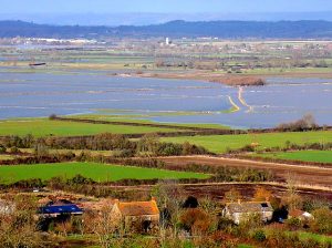
High-angle view of stone cottages in Lower Burrow overlooking green farmland and flooded fields across West Moor on the Somerset Levels.

Overview of Lower Burrow and floodwaters on West Moor in the Somerset Levels.

Regulatory Context and Site Designations

The SHRA was prepared in strict compliance with the Conservation of Habitats and Species Regulations 2017 (as amended). The assessment is necessary under Regulation 63 to determine the potential effects of nutrient changes caused by the project on the River Axe and the Somerset Levels and Moors Ramsar site. The Ramsar site supports vulnerable ecological communities, including 17 species of Red Data Book aquatic invertebrates and rare vascular plants, making it highly sensitive to eutrophication and water chemistry changes

Nutrient Loading Assessment

Stage 1 Screening identified a potential impact pathway during the operational phase of the development Foul water from the proposed residential use would be discharged to public sewers, subsequently discharging via the Wedmore Water Recycling Centre (WRC) to tributaries of the River Axe.

In Stage 2 Appropriate Assessment, the Somerset Levels and Moors Phosphorous Budget Calculator was utilized to quantify the expected nutrient output. The calculation determined that, without mitigation, the development would result in a phosphorus loading of 0.22kg TP/yr (Post 2025), a figure that includes a 20% precautionary buffer. Any unmitigated increase in phosphorus could adversely affect the conservation objectives of the Ramsar site.

Mitigation and Nutrient Neutrality

To eliminate adverse effects on site integrity, mitigation measures were formally integrated into the project plan. The calculated budget of 0.22kg TP/year will be entirely offset through the purchase of Phosphorus Credits. The reservation of these credits will be secured as a pre-commencement condition, managed and monitored by Somerset County Council.

With this mitigation applied, the additional nutrient load from the development is reduced to zero, rendering the project entirely phosphorus neutral. The assessment concludes that the project will not adversely affect the integrity of the Somerset Levels and Moors Ramsar Site or the River Axe.

For more information on our environmental assessment capabilities and nutrient neutrality calculations, please visit our Habitats Regulations Assessment services page.

Please contact us if you would like a fixed price quotation.
Lighting Assessment Completed for Residential Project in Torquay, Devon

Lighting Assessment Completed for Residential Project in Torquay, Devon

Southwest Environmental Limited (SWEL) recently delivered a comprehensive, short lead-time lighting assessment for a residential dwelling redesign in Torquay, Devon, within the Torbay Council planning authority area.

The site is bordered by mixed woodland and residential gardens, where records confirm the presence of light-sensitive species, including the Greater Horseshoe Bat (Rhinolophus ferrumequinum). The primary objective was to deliver a compliant lighting strategy for residential occupancy while mitigating artificial light spill into sensitive ecological receptors.

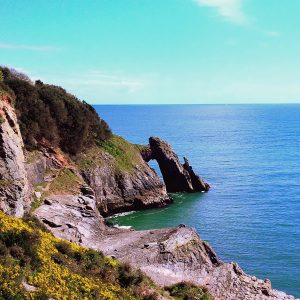
Scenic view of London Bridge Arch, a natural limestone rock arch, jutting into the sea from steep cliffs covered in yellow gorse in Torquay, Devon.

London Bridge Arch along the coastal cliffs in Torquay, Devon.

Legislative Framework and Industry Standards

Lighting assessments must demonstrate compliance with strict national policy and technical guidance to secure planning approval. Key regulatory frameworks evaluated during this project include:

Design Strategy and Ecological Mitigation Measures

To restrict light trespass, SWEL developed a targeted mitigation design. Quantitative light spill modelling was conducted across horizontal ground planes and vertical 18-metre boundary planes adjacent to the tree lines.

The mitigation strategy specified:

  • Zero Uplighting: Elimination of all ground-mounted or upward-directed luminaires across the site to prevent sky glow.
  • Luminaire Specifications: Low-power LED downlights (2700K–3000K colour temperature) fitted with horizontal cut-offs, PIR sensors, and dawn-to-dusk controls, restricted to external doorways.
  • Glazing Mitigation: Application of specialized tinted film on south and west elevations, reducing internal light transmission through glazing by up to 95%.

Quantitative Results and Assessment Conclusions

The resulting illuminance contours confirmed that horizontal light spill remains below 0.5 lux in immediate proximity to the dwelling, dropping below 0.2 lux across wider adjacent spaces and woodland areas. Vertical luminance along northern, eastern, southern, and western boundaries is predominantly maintained between 0.2 and 0.4 lux, well below threshold levels that would disrupt bat foraging or commuting behavior.

Through rapid evaluation and precision modeling, SWEL demonstrated that the proposed scheme yields a negligible impact on ecological receptors and dark sky environments.

Please contact us if you would like a fixed price quotation.
Preliminary Ecological Appraisal for Residential Development in Wickford, Essex

Preliminary Ecological Appraisal for Residential Development in Wickford, Essex

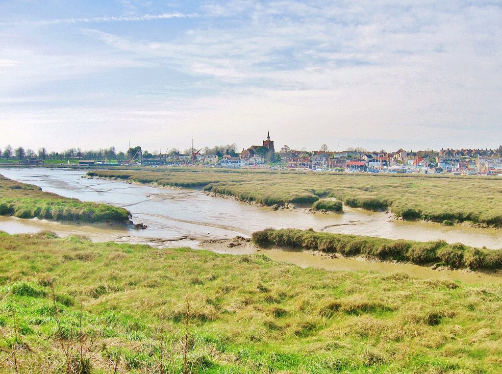
River Roach marshland at low tide in Essex, featuring exposed mud banks with visible drainage patterns, a marina with boat masts, and a distant town with a square church tower.

Low tide on the River Hythe Essex, showing exposed saltmarsh mudflats with a marina and town skyline in the background.

Southwest Environmental Limited was instructed by a planning consultancy to prepare a Preliminary Ecological Appraisal (PEA) for a proposed residential development in Wickford, Essex[cite: 4]. The site is located within the jurisdiction of the local planning authority in Essex[cite: 4]. The proposed development encompasses the erection of two chalet bungalows, alongside associated amenity space and parking facilities[cite: 4]. This ecological assessment was completed with a short lead time to facilitate the applicant’s planning submission schedule.

Methodology and Baseline Habitat Survey

A desktop review and field survey were conducted by a Project Ecologist[cite: 4]. The habitat classification was mapped following the standard methodology set out by the UK Habitat Classification (UKHab)[cite: 4]. The survey identified the site primarily as modified grassland featuring a heavily maintained, short sward[cite: 4]. Additional habitat features recorded on the site include a small area of sparsely vegetated land, a sealed surface paving area, and a line of trees situated along the northern boundary[cite: 4].

Protected Species Assessment and Statutory Compliance

The site was assessed for its potential to support protected species in accordance with the Wildlife and Countryside Act 1981 and the Conservation of Habitats and Species Regulations 2017[cite: 4]. The appraisal concluded that the site has a low likelihood of supporting bats, reptiles, mammals, and amphibians[cite: 4]. This is primarily due to the heavily managed nature of the grassland, the open exposure of the site, and a lack of suitable microhabitats or roosting features within the small trees[cite: 4].

The line of trees does present a high likelihood for supporting breeding birds and common invertebrates during appropriate seasons[cite: 4]. To ensure compliance with national legislation protecting nesting birds, any vegetation clearance or tree felling must be undertaken outside the typical bird breeding season of March to August, unless preceded by a nesting bird check conducted by a qualified ecologist[cite: 4].

Site Evaluation and SSSI Proximity

Desk studies indicated that the site is located within the Impact Risk Zone of Influence for the Crouch and Roach Estuaries Site of Special Scientific Interest (SSSI)[cite: 4]. This SSSI is designated for its intertidal mud, saltmarsh, and grazing marshes, which support internationally important numbers of Dark-bellied Brent Geese[cite: 4]. Due to the low biodiversity value of the proposed development site, its former agricultural nature, and poor habitat quality, the project is anticipated to have a negligible effect on the SSSI[cite: 4].

Ecological Recommendations and Conclusion

The site is evaluated as having low nature conservation value at a county or district level[cite: 4]. Consequently, no further Phase 2 protected species surveys are recommended for this project[cite: 4]. To achieve localized biodiversity enhancements, the implementation of native pollinator plant species, bat boxes, and bird boxes has been formally advised within the site plan[cite: 4].

For more information on our environmental surveying capabilities, please visit the Preliminary Ecological Appraisal services page on www.southwest-environmental.co.uk.

Please contact us if you would like a fixed price quotation.

Preliminary Ecological Appraisal – Yeovil, Somerset

Preliminary Ecological Appraisal for Proposed Agricultural Development in Somerset

Southwest Environmental Limited recently prepared a Preliminary Ecological Appraisal (PEA) report for a surveying firm in Yeovil, Somerset. The site is positioned within the planning jurisdiction of South Somerset District Council. The appraisal was commissioned in connection with the proposed development of a single farmworker’s dwelling and an associated parking area. Our team completed the necessary ecological surveying and reporting with a rapid turnaround.

Methodology and Scope of Works

The ecological appraisal was conducted in strict accordance with industry standards, incorporating the CIEEM Guidelines for Ecological Impact Assessment (2024). The assessment commenced with a desktop study to identify statutory designated sites, local habitats, and geo-spatially tagged species within the site’s zone of influence. The site is located inside the Site of Special Scientific Interest (SSSI) Impact Risk Zones of Influence for multiple biological sites, including Grove Farm and Whitevine Meadows. The desktop phase also verified that the site is located 1,155 metres north of the Dorset National Landscape, an Area of Outstanding Natural Beauty. Following the desktop review, a Phase 1 habitat survey was executed to classify and map the habitats present, adhering to the standard UK Habitat Classification (UKHab) system. Further details regarding our ecological assessments can be found on the Southwest Environmental Limited ecology page.

Habitat Classification and Species Assessment

The surveyed site predominantly consists of modified grassland, covering approximately 1,618 square metres, and is characterised by a short sward dominated by perennial ryegrass. The eastern and southern boundaries contain continuous sections of mixed scrub, measuring approximately 182 square metres, comprising species such as bramble, common nettle, field elm, and elder.

During the field survey, the site was systematically evaluated for its potential to support species protected under national legislation, including the Wildlife and Countryside Act 1981 (as amended), the Conservation of Habitats and Species Regulations 2017 (as amended), and the Natural Environment and Rural Communities (NERC) Act 2006. The assessment concluded that the mixed scrub boundaries offer suitable nesting habitat for common and widespread bird species Additionally, the site provides potential foraging and commuting habitats for mammals, such as hedgehogs, and various terrestrial invertebrates. The preliminary protected species assessment also investigated the potential for roosting bats; however, the absence of onsite trees, buildings, and suitable roosting features led to a low likelihood of roosting bats being present. Similarly, the site offers sub-optimal terrestrial habitat for great crested newts due to the lack of dense tussocky cover and aquatic breeding features.

Conclusions and Site Enhancements

The overall nature conservation value of the site was determined to be low. The proposed residential development is anticipated to have a minimal ecological impact, provided that specific precautionary mitigation measures are implemented prior to and during construction. These essential measures include the directional mowing of grassland to displace any potential reptiles and the scheduling of scrub clearance outside of the active bird nesting season, which typically occurs from March to September inclusive. Consequently, no further Phase 2 species-specific surveys were deemed necessary for this project.

The development presents actionable opportunities to enhance the site’s biodiversity. Recommendations include native hedgerow planting, the creation of log piles, the installation of bat and bird boxes, and the incorporation of permeable boundaries featuring hedgehog gaps in new fencing.

Please contact us if you would like a fixed price quotation.

Lighting Assessment for Residential Development Near Woodland Habitat

Lighting Assessment for Residential Development Near Woodland Habitat

Southwest Environmental Limited was recently instructed by an architectural firm to produce a Lighting Assessment for a proposed residential development. The site is located in Buckland Ripers, Dorset, and falls within the planning jurisdiction of Dorset Council.

The Development

The proposed development comprises the construction of a single residential dwelling, a garage, and an associated garden. Environmental constraints were a primary consideration for this site. The location is situated 1.6 kilometres from the Dorset National Landscape Area of Outstanding Natural Beauty (AONB). Furthermore, a woodland area is located just over 20 metres to the south of the proposed dwelling. Ecological surveys previously conducted at the site identified the presence of Myotis bats within this woodland. Myotis bats are known to be highly sensitive to artificial light, necessitating careful planning and mitigation.

Objectives

The objective of our Lighting Assessment was to design a lighting scheme that meets the safety and operational requirements of the future human occupants while preventing light spill that could negatively impact the adjacent bat habitat. The assessment was conducted in accordance with relevant legislation, including the Planning (Clean Neighbourhoods and Environment) Act 2005, and national planning policies which require new developments to limit the impact of light pollution on nature conservation.

To achieve the necessary control over light emission, we developed a strategy adhering to the guidelines set out by the Institute of Lighting Professionals and the Bat Conservation Trust. External lighting is restricted to narrow-beam, horizontal cut-off LED downlighters mounted at low elevations, specifically 0.6 metres and 1.6 metres above ground level. These luminaires will be fitted with passive infrared (PIR) and dawn-to-dusk sensors to ensure they are only active when required. We specified a warm colour temperature range of 2700k to 3000k to minimise the ultraviolet light output, which is known to attract insects and disrupt bat foraging patterns. Up-lighting was strictly prohibited across the entire site.

A bright, modern lecture space with large windows and colorful blue, yellow, and red tiered seating.

A Well Lit Space

Internal light spill was also evaluated as a critical factor due to the proximity of the southern woodland. To address this, the design incorporates electrochromic glass on the windows of the front entrance. This dynamic glazing activates when internal lighting is switched on, providing up to a 90 percent reduction in visible light transmission through the glass.

Method & Outcome

We utilised lighting design software to model the proposed external and internal lighting, producing lux contour plans for both horizontal and vertical planes. The quantitative analysis demonstrated that horizontal light spill on the ground would remain below 0.5 lux around the immediate development, dropping below 0.2 lux well before reaching the woodland edge. Vertical luminance along the woodland boundary was also shown to be predominantly below 0.2 lux, ensuring the bat habitat remains sufficiently dark. Construction phase mitigation measures were also detailed to prevent temporary light spill during the build.

This comprehensive analysis and the accompanying mitigation strategy were completed with a short lead time to assist the client in maintaining their planning submission schedule.

Please contact us if you would like a fixed price quotation.
Preliminary Ecological Appraisal (PEA) – Bridport, Dorset

Balancing Development and Biodiversity in Dorset

Designing with Nature: A Success Story Near Bridport

When planning any new development, understanding the local ecology is the first step toward a successful build. A Preliminary Ecological Appraisal (PEA) was conducted for a proposed farmworker’s dwelling and parking area near Bridport, Dorset. The assessment highlights how tailored mitigation measures can keep a project moving forward while fully respecting the surrounding landscape.

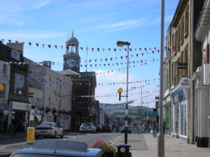
Bridport Town Centre (Stock Image)

Understanding the Landscape Baseline

The development footprint itself sits on managed modified grassland and a small patch of mixed scrub, which holds low nature conservation value at a local level. However, because the site is nestled within the beautiful Dorset National Landscape and falls inside the Impact Risk Zones for two nearby Sites of Special Scientific Interest (SSSIs), the wider environmental context required careful navigation.

Key Ecological Findings & Solutions

While the on-site survey revealed that the immediate plot has low ecological sensitivity, an old stone agricultural building directly adjacent to the boundary presents unique factors:

  • Protecting Nocturnal Wildlife: The neighboring building contains features suitable for roosting bats. To prevent domestic light spill from disrupting these nocturnal animals and to comply with local Dark Skies policies, a Phase 2 Lighting Assessment has been integrated into the next steps of the design process.

  • Safeguarding Nesting Birds: Active swallow nests were confirmed nearby, and the boundary vegetation offers excellent habitat for common breeding birds. To remain fully compliant with wildlife legislation, high-impact construction works and vegetation clearance will be strictly scheduled outside the peak nesting season (March to September).

Building a Greener Future

Beyond protecting what is already there, the project presents an excellent opportunity to deliver active biodiversity gains. Final development plans will incorporate pollinator-friendly landscaping, bat boxes, and bird boxes to ensure the new home gives back to the local ecosystem.

How many BNG Credits per Acre?

How many BNG Credits per Acre?

If you are considering giving up some of you farm land for BNG credits, then of course you will need to know how many BNG credits you will get per acre. The land you are giving up for BNG will be out of use for many years and as such it is only right to investigate the returns you might expect.

BNG Credits are created by changing land from one use to another. For example a field to woodland, or some low lying meadows in to wetlands.

Not Just “How Many”

The first thing to realize is that it is not just a case of “how many”. As with wine or stamps the price of credits varies based on “distinctiveness“. Grassland may have quite low “distinctiveness”, whilst a lake would have very high distinctiveness. This can affect the price of each credit by 400%. (£40,000 to £200,000 or more).

Wetlands are a Very Good Option for BNG

But. How Many BNG Credits per Acre?

The short answer might be about 1 BNG Credit per Acre. Or 2 BNG Credits per Hectare.

This is based a few real world examples we have worked on where say 4 hectares of marginal land yielded around 7 BNG Credits.

But of course it is not that simple. The credits come from improvements in biodiversity. So if you start with good bio diversity (say scrub) then you will gain less when you “upgrade” to woodland.

Your best possible “yield” would be to upgrade mono-cultural farmland to something like a swamp or lake. But in terms of profit (especially in the long term) perhaps it is better to use scruffy marginal land and make fewer credits.

A last word. If you are think perhaps you could “tidy up” an area and then re-wild it in a year of two remember that what you do is all being recorded by satellites (google earth), and part of the process if proving that the land has not recently been changed.

Prices Can Vary Per Unit

Want to Know More

If you would like to know how much money you could make from BNG credits, then please do contact us (wt@southwest-environmental.co.uk) and we can arrange for our ecologist to advise you on the best way forward.