Category Archives: Flood Risk Assessment

Flood Risk Assessment – Merton

Flood Risk Assessment – Merton

SWEl have recently prepared a Flood Risk Assessment for an interesting proposed development in Merton (New Maldon).

The development sees the retention of a existing building for conversion under PD rights, and the creation of e neighbouring residential unit.

Below images show various mapping used in the compilation of the report.

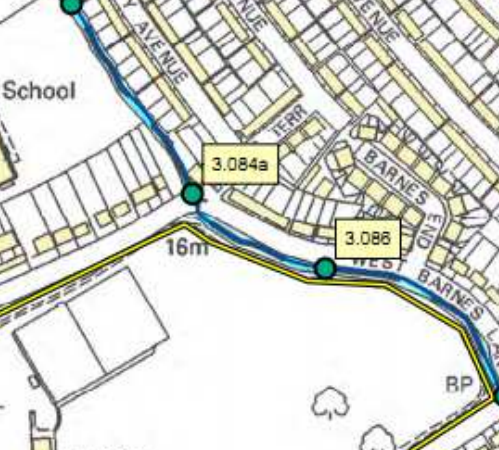
Flood Extent Mapping in Merton
Modelled flood data was obtained and used in describing the site as low risk. 

Model Nodes used in 2D Models
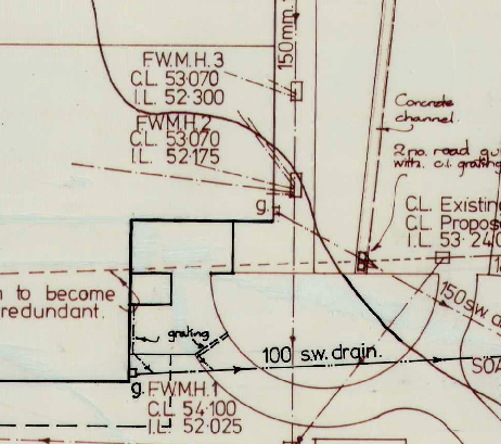
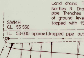
Both 1D and 2D flood modelling data was used, the nearest water course was the Beverly Brook. 

A Considerate Design improves Planning Success
The Flood Risk Assessment also considers surface water run-off, thankfully the development was considerately designed with large areas of soft landscaping. 

Flood Risk

Environment Agency Flood Data – Thames Estuary

Until recently I was using the following email address to get flood data and maps for the thames estuary:

corporate.services@environment-agency.gov.uk

this email account will soon be closed, the new email to use to contact us will be

ensenquiries@environment-agency.gov.uk

Despite having used the original address for a number of years I received no notice that it would be changed, and have found out the above via lengthy googling.

Hopefully it will save you the time!

In this day an age, would it not have been possible to email past customers to tell them about the change prior to closing the account?

Flood Risk

Geotechncial Site Investigation – Devon

Site Investigation – Devon

Acting upon instruction from a management company located SWEL are to undertake a Geotechnical ivestigations at a holiday park near Totnes.
SWEL provide a wide range of geotechnical and environmental services to support our clients with there chosen projects. 
In this case SWEL are to prepare a retrospective specification for a raft foundation, to satisfy the local authorities requirements. The slab as stands, would appear to be installed to a very high standard, and is liklley over specified, and reside upon desnse gravels.

Flood Risk Assessment – Bristol

Flood Risk Assessment – Bristol

SWEL have been commissioned to prepare a flood risk assessment for a mixed use development in Bristol.

The scheme comprises of commercial use of the ground floor, with residential use above. This is a favorable situation, as the ground floor use is less vulnerable as define in the planning practice guidance.


The stated aim of PPG is to ensure that flood risk is taken into account at all stages in the planning process to avoid inappropriate development in areas at risk of flooding, and to direct development away from areas at highest risk. 


This FRA is prepared for the purposes of providing a generalised indication of the potential flood risk to the site, and to identify whether there are any flooding or surface water management issues relating to the development site that may warrant further consideration. 

Bristol is a varied city with regards to flood risk. Some of the hilly areas see very rapid lowering in flood risk moving away from water courses, however area to the west such as Avonmouth experience large areas of low lying ground in Zone 3a which can be problematic from a planning perspective.

There are numerous culvert water courses in Bristol, where rivers has been built over, and now run in tunnels under central areas. 

The flood risk assessment will be prepared on a quick turnaround and supplied to the client in a PDF format.

The use of secondary data will aid in providing this report on a quick turnaround. 

Flood Risk Consultants Bristol

Surface Water Drainage Strategy – East Devon

Surface Water Drainage Strategy – East Devon

In proving a Surface Water Drainage Strategy to the planning office when submitting a planning application, it makes clear how surface water drainage will be handled within the new development.

Surface water drainage will have to be carefully considered when the project involves large areas of impermeable surfaces.

In this instance an artificial sports pitch surface was to be renewed in and the opportunity was taken to check the adequacy of the surface water drainage on site.

SWEL undertook attenuation calculation in line with the relevant guidance, but were careful to estimate an appropriate attenuation value for the pitch surface.

The current pitch surface would seem to be impermeable but this would not have been the case when the pitch was first installed. By research the subject SWEL were able to determin that the pitch sand (which would be free draining) had becomh contaimanted with fine grained soils (clays etc.) that had reduced its permeability and thus increases run-off potentially.

These characteristics had no doubt developed over the life spane of the exist surface and so to specify draining based on the aged, low permeability surface would have been to over specify.

Instead an average value was used between that of a new surface and that of the surface as was observed.

Legacy Drainage Plan, were used to derive current state of drainage.

Pitch condition reports were used to derive condition of surfaces.

High Quality Legacy Plans helped to facilitate the writing of the report.

Surface Water Management Plan

Flood Risk Assessment Hammersmith and Fulham (W6 9HB)

Flood Risk Assessment Hammersmith and Fulham (W6 9HB)

Acting on instruction received from an architect SWEL have prepared a flood risk assessment for a residential conversion. The scheme was well designed, and the site well placed (interms of level) so as to require the minimum of consideration with regards to resilient design.

High quality modelling data was used to provide a design finished floor level, that was at a very low risk of flooding, the report is being assessed at present with Hammersmith and Fulham Borough Council, and based on our track records SWEL are confident that the report will be well received.

Flood Risk Assessment Reports

Flood Risk Assessment Dartmouth

Flood Risk Assessment Dartmouth 

SWEL were approached by a private land owner in Dartmouth, who had an old garage that they wished to convert to residential use.

A scheme was developed that saw a building designed to be minimally affected in the event of flooding. Ground floor living accommodation was not included in the scheme, instead the living accommodation was included only on the 1st floor.

The 1st floor accommodation was proven to above likely flood depths via the use of detailed flood modelling data, which showed the site to flood to a round depth of 0.6 meters in a very bad flood.

Despite a thorough report concerns were raised over flood safety, the main objections coming from the Environment Agency, and as such they were in a mind to refuse the application.

Despite the flood maps showing a depth of 0.6 meters they do not specify a duration for the flood. However thinking pragmatically this is only likely to last 4 – 6 hours owing to influence of tides, it was this concept put forward by SWEL and presented to district council’s development committee, with a successful out come.

Such was the surprise at the persistent objections from the Environment Agency, that the application had some coverage by the local press.

Flood Risk Assessment Reports

Flood Risk Assessment – Exmouth

Flood Risk Assessment – Exmouth

If you find out that your site is in Flood Zone 3a this does not mean that you will not be able to build on / develop the site. There will be more paper work, and you may have to wait some time for the Environment agency to decide whether your site is in fact suitable, but in 90% of cases Zone 3a will not pose as an insurmountable barrier.

Such was the case with a site in Exmouth, near Exeter, Devon where an infill building plot, was partially within flood zone 3a. It was quickly established that a variance in ground elevation was the cause of this  incursion, and that likely ground raising associated with the proposed develop would effectively place the proposed dwelling above flood water levels.

Flood Risk

Sequential Test for Planning Application – Catterick, North Yorkshire

Sequential Test for Planning Application – Catterick, North Yorkshire

It can be the case that planning authorities will take exception to a particular project and make requests for all kinds of extra information, to support the application, at a level of detial that would not normally be required.

Southwest Environmental were approached by a developer who was building a number of residential units in a Flood Zone 3. An initial flood risk assessment had been undertaken previously by a consultant and appeared to be of sufficient detail, however the local planning authority required extra clarification with regards to the sequential test.

SWEL have an well proven method for carrying out sequential test, and this was applied once more in this instance.

The project was well considered with regards to flood risk, the buildings design and choice of materials were  well chosen.

Sequential Test Consultants

Flood Risk Assessment – Wandsworth (SW11)

Flood Risk Assessment – Wandsworth (SW11)

Southwest Environmental have just completed a Flood risk Assessment for a small project in Wandsworth London.  The development saw the retention of a typical terraced house with an extension to the rear.

The property had a basement to include living accommodation but not sleeping accommodation. This is an important differentiation.

The sequential test was not required for this development as it is a domestic extension.
If you would like a flood risk assessment carried out in wandsworth, then please gt in touch, are prices are reasonable and our service prompt.